Category Archives: Maps

2001 – MondoGIS – The Sardinian Industrial Parks Geographic Information System


Written with Sergio Loddo (Regione Sardegna).

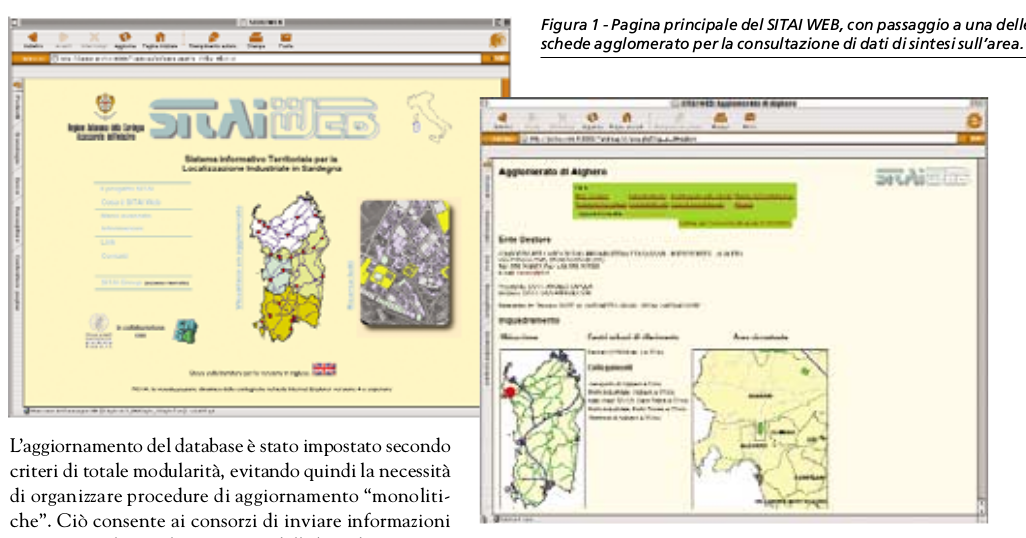
As far as I recall this was one of the first multi-language web GIS applications in Italy (pulished in 2000). The aim of the project was to provide a site selection interface to promote the transfer of parcels being freed by declinining heavy industries to small and medium enterprises.

For the techies

Developed in PHP, the Jshape applet for mapping (no longer available), and an Oracle back-end. Before the web version, between 1997 and 1998 I designed and deployed a desktop version. This was based on ArcView 3.2 and MS Access. A feature of interest: the APR files for the fifteen industrial parks were generated via Avenue scripting with style parameters retrieved from a database so as to simplify the generation of subsequent versions of the interface.

The system also included a geographic web log mining component (explained in the article).

See PDF (in Italian).

For more information: info@pibinko.org

MULINO

2001

For the MULINO EU-funded research project (on Multi-sectoral  Integrated and Operational decision support system for sustainable use of water resources at the catchment scale ) I provided the review of the specifications for the GIS interface and curated multilingual aspects of the software.

SITAI – Information System for Industrial Parks in Sardinia

Mondo GIS n. 48 – 2001 – http://www.sardegnastatistiche.it/documenti/12_117_20061221100041.pdf

http://www.sardegnastatistiche.it/index.php?xsl=356&s=36627&v=2&c=3104

http://www.crs4.it/Publications/cgi-bin/crs4-bib.cgi?opt_style=page&opt_selectid=gialor00b&opt_selecttype=TechReport

http://www.crs4.it/Publications/cgi-bin/crs4-bib.cgi?opt_style=page&opt_selectid=Giacomelli:2000:SPI&opt_selecttype=TechReport

http://www.crs4.it/Publications/cgi-bin/crs4-bib.cgi?opt_style=page&opt_selectid=Giacomelli:2001:SWA&opt_selecttype=TechReport

http://www.crs4.it/Publications/cgi-bin/crs4-bib.cgi?opt_style=page&opt_selectid=gialodlor00&opt_selecttype=InProceedings

http://www.crs4.it/Publications/cgi-bin/crs4-bib.cgi?opt_style=page&opt_selectid=gialodlortid00&opt_selecttype=InProceedings

http://www.crs4.it/Publications/cgi-bin/crs4-bib.cgi?opt_style=page&opt_selectid=gialor00a&opt_selecttype=TechReport

http://www.crs4.it/Publications/cgi-bin/crs4-bib.cgi?opt_style=page&opt_selectid=gialodlor98&opt_selecttype=InProceedings

Industrial park information system (SITAI)

1997-1999 (in various phases)

For CRS4: I designed and developed the SITAI system.

The system provided a desktop (and subsequently a multi-language web-) interfact to visualize and query data for site selection of parcels in the Sardininian industrial parks.

In 2001 I also conducted a spatial analysis of the system’s web logs.

Contributions to the shapelib library

I almost forgot, but I recently re-discovered that I once contributed to the developement of the shapelibe libraries http://shapelib.maptools.org/ – see the “Credits”


Credits
I didn't start this section anywhere near soon enough, so alot of earlier contributors to Shapelib are lost in pre-history.

    Bill Miller (NY-DOT) for shputils.c
    Carl Anderson for the contents of the contrib directory, and the "tuple" additions to dbfopen.c.
    Andrea Giacomelli for patches for dbfopen.c.
    Doug Matthews for portability improvements.
    Jan-Oliver Wagner for convincing me to make it available under LGPL, shared library support, and various other patches.
    Dennis Christopher (of Avenza) for testing and bug fixes.
    Miko Syrjä (of 3D-system Oy) for a record size bug fix.
    Steven Lime and Curtis Hill for help with NULL shapes.
    Jim Matthews for support of NULL attributes in dbf files.
    PCI Geomatics who let me release a modified version of their shapefile code in the beginning and who hosted shapelib for years. 

Coastal aquifers

1998

At CRS4: Information systems support (including task automation and web interfaces) to saltwater intrusion modelling in three mediterranean countries (Sardinia, Tunisia, Morocco).

I also provided training sessions in French (in Tunisia and Morocco) about GIS.

HYREC project

1994-1997

At Politecnico di Milano: GIS-based integration of data from distributed hydologic modelling and remote sensing data for surface soil moisture estimation (in the context of the HYREC EU-funded research project).

EARSeL Specialist Meeting on Hydrology and Water Resources, Dundee, Scotland, 1993

During the Spring of 1993 my MS Tutor at the University of Gent, Peter Troch, was invited for a presentation in a workshop in Dundee, Scotland.

Peter had a very busy schedule at the time, and Dundee was not really close to Gent.

He then suggested that his two Erasmus students (Ugo Bacchiega and myself), who were in the final steps of their dissertation work, could take his place and present our work at the workshop.

So we went, and gave a presentation on “GIS-based integration of SAR remote sensing and distributed hydrologic modelling for surface soil moisture estimation”.

I have always thanked Peter for this opportunity.

The trip do Dundee was indeed very long (ferry boat + train!), but the experience was very educational.