Category Archives: Maps

Come to Tatti (Southern Tuscany) for the metalliferous version of the 2019 International Open Data Day

The Open Data Day is an international event, in its ninth edition, celebrating open data, and its meaning for governments, business, and society all over the world. If this sounds a bit geeky, consider that many public bodies have adopted for some years now open data policies, and that the private sector is not ignoring the topic. You may also check out this short video for an introduction to the topic (and to have a peek of Tatti in the first seconds).

Pibinko.org uses free/open-source software since 1994, and is actively promoting it since 2004 . In 2008 pibinko.org also started promoting open data, either by promoting specific OpenStreetMap initiatives (such as the m(‘)appare Milano) project, or by producing videos and other communication on this topic (or both).

M(‘)appare Milano, episode 1, Apr. 6, 2008

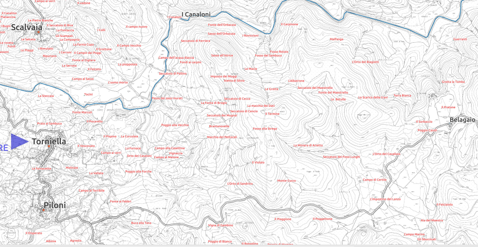
Also in 2008, the network started creating original data sets. First with the citizen science campaigns on night sky quality with BuioMetria Partecipativa (2009), then, in collaboration with various amateur astronomic observatories, with the creation of the Italian network for light pollution data collection (CORDILIT, since 2011). Our array of data grew then in 2014 with the Farma Valley Community Map, which was cited last year in a Worlb Bank report among 50 best practices of re-use of governmental data by local communities.
The bottom-up place name mapping is the story which pibinko.org proposes also in the 2019 edition of the Open Data Day, adding a new venue, following the Open Data Days in Piloni (2013) and Scansano-Torniella-Castelnuovo Val di Cecina (2017).

The first Tatti Community Map meetup (Dec. 14, 2018)

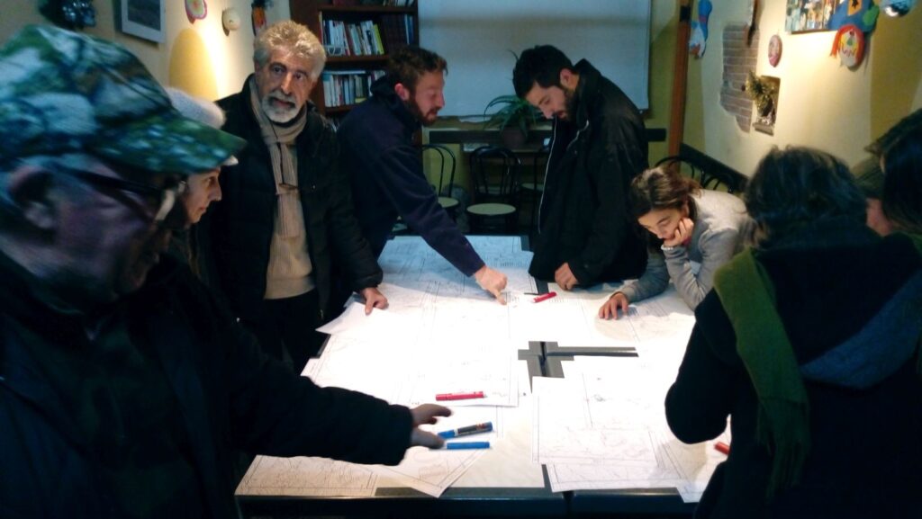
You can join us on Saturday, March 2, 2019 at 6.00PM in Tatti (Southern Tuscany), this is the part of the metalliferous hills where you can see the sun set behind the Elba Island. The meetup will be at the “circolino”, a small community center, where we will continue to interview and digitizing work started last December in the Third Farma Valley Winter Fest. There is a geographic link between the Farma Valley and Tatti, since the Farma creek originates in fact just North of Tatti, very close to where the locals work and operate (in addition to personal relationships between these communities, encouraging us to merge these two maps).

For more information: info@pibinko.org o +3317539228


View Larger Map

m(‘)appare

m(‘)appare is a word I created in 2008 for the m(‘)appare Milano project. it encompasses various ideas on mapping, beholding etc …this section will be update shortly – please write to info@pibinko.org for more details.

Support to Legislation and Policy Making

Since 2004 I have periodically participated to initiatives or actual projects related to the definition of policies and regulations at different territorial scales, from municipal to global.

Local (municipal) level

I attended various participatory design initiatives related to environmental or land planning issues in Cagliari (Sardinia), Gavorrano, Scarlino, and Roccastrada (Tuscany). Since 2004.

In 2015, in my role as Attivarti.org president, I attended the definition of the participatory budget for the town of Grosseto (capital of Southern Tuscany). Here I presented a proposal for the protection and promotion of nightscapes, oriented to benefits for citizens.

Local (province) scale

In 2009 I participated as an expert to the public review of the tender subsequently issued by the Province of Grosseto for the co-funding of a science and technology park on mechanics. This is active since 2016 in Cinigiano, Southern Tuscany.

In 2011 I took part in a participatory design workshop called “Chiamati in causa per investire” (i.e. “Called to invest”). This was proposed by the Province of Grosseto for the prioritisation of about 40 MEUR of public spending. Out of various ideas and proposal recored during the workshops, in the final session of the event one of the rapporteurs mentioned palla a 21 and buiometria partecipativa)

Local (regional) scale

In collaboration with Francesco Giubbilini, based on the BuioMetria Partecipativa project, we participated in 2012 to the public consultation concerning the revision of Tuscany’s Environment and Energy master plan. We provided eight comments, four of which were accepted. Among others, the plan acknowledges night sky as a resource for tourism and environment.

National scale

I was invited to take part in the drafting of part of a national law (however I could not participated due to technical issues)

European Union scale

In 2010 I was part of a European Commission working group for a workshop on EU policies on the Digital Earth initiative. The ideas defined in this workshop have been consolidated in an article on “A European perspective on Digital Earth“.

In 2011 I was invited at a workshop jointly organized by the European Commission’s Joint Research Centre and NASA for the ideas on key areas for research funding (Socio-economic Benefits from the use of Earth Observation). On that specific occasion I proposed a presentation called “Accounting for People in Earth Observation – Some Experiences from Italy” . The workshop proceedings are available.

Between April 2012 and October 2012 I was appointed as the facilitator for a working group of five experts for the creation of the data specifications for the “Production and Industrial Facilities” theme (Annex III of the European INSPIRE Directive on spatial data infrastructures).


Global scale

In 2015 I was selected as one of the Italian citizens for a meeting leading the collection of ideas to be reported to the Italian government for the definition of the COP15 Paris agenda. Namely, I attended the meeting in Florence.

m(‘)appare

This is a term I created in 2008 to encompass the ideas of mapping and beholding. In Italian mappare means “to map” and m’appare “something appears to me”.

As far as I know, the term m(‘)appare was proposed for the first time by myself in March 2008, during the launch of the  M(‘)appare Milano, mapping campaign, when I was collaborating with  GFOSS.it (the Italian chapter of the Open Soruce Geospatial Consortium).

This term was created to have a localized version of the “mapping parties” held by the OpenStreetMap community and which in Italy had previously taken place in  Alto Adige,  Pavia and Arezzo.

The Italian free/open mapping community liked the term and the concept of m(‘)appare, and re-used this with GFOSS.it on m(‘)appare, Ferrara, Portofino, Verona, and Mounte Antola, near to Genova.

I also had several opportunities to present and debate the ideas related to m(‘)appare in various events (Creative Commons Festival Parma, Politecnico ed Ecomuseo Urbano Milano Nord a Milano, IUAV Venezia, GRASS meeting Lugano, GFOSS Day Bolzano). As a sidebar action, videos and rhymes related to m(‘)appare appeared (Riflessioni sul tema(tismo)  , Allora vi faccio vedere come ho fatto, Pressioni di Settembre e Renato lo Scienziato).

Not just geomatics processes and points of interest

After a first phase of m(‘)appare, mostly focused on geomatics and digital land maps, the topic became broader, and we started talking about mapping the upper half of the landscape (i.e. the night sky), leading to the BuioMetria Partecipativa. project on participatory monitoring of light pollution.

Eventually we started to use the term m(‘)appare non just with reference to things and places, but also to people (e.g. the  m(‘)appare Maurizio Bacci event during the Farma Valley Winter Fest in December 2016).

In a nutshell

As we can see it after ten years, the scope of m(‘)appare is on engaging people to see things or places with a bottom-up approach, focusing mostly in things and places which are not very known.

The two main m(‘)appare initiatives to date are:

More info: info@pibinko.org.


26-12-2015


Geographic Information Systems and Databases

Since 1993 I have worked on Geographic Information Systems and data management (mostly, but not only, environmental data). Selected projects cover:

  • Integration of radar remote sensing data and distributed hydrologic models
  • Satellite-based assessment of flooded areas
  • Site selection and promotion of industrial parks
  • Decision support systems for water resource management
  • Text and web log mining
  • Tourism
  • Data conversion (from CAD to GIS and from GIS to GIS)
  • Utility surveys (in large industrial facilities and in extended regions)
  • environmental site characterisation and remediation
  • Spatial analysis to support the design of large remediation wetlands
  • Hiking trails

Web

  1. http://www.pibinko.org (since 2008, various versions)
  2. http://www.pibinko.org/pib – my blog (2011)
  3. Attivarti.org – social activism (2011)
  4. BuioMetria Partecipativa (with Francesco Giubbilini, since 2008, various versions)
  5. palla21.it – on the game of Palla a 21 (or Palla Eh!) (since 2007, various versions)
  6. Toscana Foto Festival (2014-2015) (note: the site was dismissed in 2016 following a re-organization of the Festival)
  7. CORDILIT – Collection of data for light pollution monitoring (2011)
  8. Associazione Filarmonica Popolare di Torniella (GR) – a community marching band (2012)
  9. Mostri di Media Dimensione – Movie by Lucio Monocrom (2013)
  10. Officine Pandino – video productions (only hosting, 2012)
  11. Ricette Bone – Tuscan recipes, recommended by aunt Eda (2009)
  12. Ermanno X, la notizia che uccide.  Movie by Lucio Monocrom (2009)
  13. La Vendetta del Chihuahua Killer e degli zombi. Movie by Lucio Monocrom
  14. Circolo ARCI LO-FI – Live music in Milano, Italy (2010)
  15. Caffé Ricasoli, in Grosseto, Italy (2011)
  16. Agriturismo Casa del Chiodo, Piloni (GR), 2010
  17. Emiliano Baldi, artist (2011)
  18. Fra il tramonto e l’alba – photography competition (2010)
  19. Le palline sulle colline – photo exhibitions and competition(2008)
  20. Toscana Stellata (con Francesco Giubbilini, 2012)
  21. GIS LAB page for CRS4 (1997-2002)
  22. SITAI WEB, web GIS for the indutrial parks of Sardinia (1999 – no longer online) -see article on  Mondo GIS,  Sep. 2001 (in Italian)
  23. Information system for local development (2000-2004- no longer online) – see article by FORMEZ (in Italian)
  24. Specifications and management for a Sharepoint system for a large environmental program in Europe (2006-2010)
  25. web GIS within the  SHAPE  project (2013)
  26. web site for the “Falde costiere” project (2001)

A new edition for the Farma Valley Community Map

After about a year from its first publication (see post), an updated version of the Farma Valley Community Map was published. The creation of the map started in 2014, with points of interest being gradually added to the official 1:10000 base maps, leading to document water springs, old gardens, hunting sites and other toponyms related to the life of the communities of this lesser known part of Southern Tuscany.

With respect to the previous version, the map has bee enriched with place names provided in the past months by the Community of Scalvaia, and the area of interest has been expanded to the East, including Poggio alle Pigne, while new surveys are being conducted in this area. Last but not least, the readability of the map has been improved.

The data collected are made available as open data and are published on the Tuscan Region  Open Data portal.

Kudos to Pro Loco Piloni-Torniella for supporting the printing, and once more to the communities of Torniella, Piloni and Scalvaia for the data which they are sharing.

For more information: info@pibinko.org