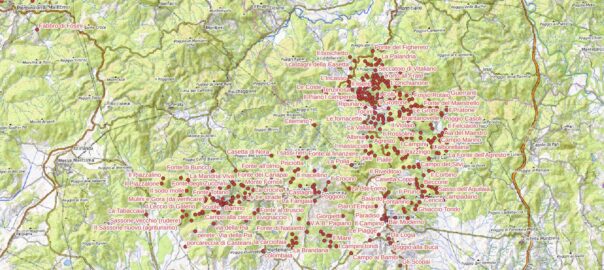
This map represents the progress in the collection of “community place names” in the pibinko.org network projects.
These are localities and other geographic features which currently are not represented in official base maps (namely, the 1:10000 so called “technical regional cartography”). For the various areas we have engaged, we indicated the starting year. All communities of the participating villages are acknowledged.
- Val di Farma “South” (Torniella and Piloni): 2014. the first version of these place name is also available on the Regione Toscana Open Data portal: https://dati.toscana.it/dataset/toponomastica-partecipata-della-val-di-farma)
- Val di Farma “North” (Scalvaia): 2017
- Tatti: 2018-2019
- Roccastrada: 2020
- Roccatederighi: 2022
- Monterotondo Marittimo: 2022
- Montemerano – ongoing, in collaboration with CIRCOLARE. Waiting for data (see link, in Italian).
If you click on one of the points you will see a list of pibinko.org articles referring to that location.
- If you would like to add your area to the map (the project operates globally…we started with Southern Tuscany but we like to keep a wide angle on our work), or you would like to recommend fixes to the current points, or retrieve a copy of the data (which is available as open data) please contact micalosapevo@pibinko.org or +393317539228.
- For more articles about our community maps: https://www.pibinko.org/it/?s=mappa+di+comunit%C3%A0 and https://www.pibinko.org/jugbandcollinemetallifere/?s=mappa+di+comunit%C3%A0 – the links are in Italian, but you will find interesting characters.
- To support the improvement of the map: https://www.pibinko.org/support/
